Amid the escalating tensions between Iran and Israel, the United States military early Sunday struck three nuclear sites in Iran — Fordow, Natanz, and Isfahan, with US President Donald Trump warning the Islamic nation that they would target additional sites if peace was not achieved. The strikes come after a week of Israeli strikes on Iran in an attempt to systematically wipe out the latter’s air defences and offensive missile capabilities, while damaging its nuclear enrichment facilities.
Buried under a mountain about 100 km southwest of Tehran and guarded by anti-aircraft batteries, the facility at Fordow and the enrichment plant at Natanz are among Iran’s most critical uranium enrichment centres.
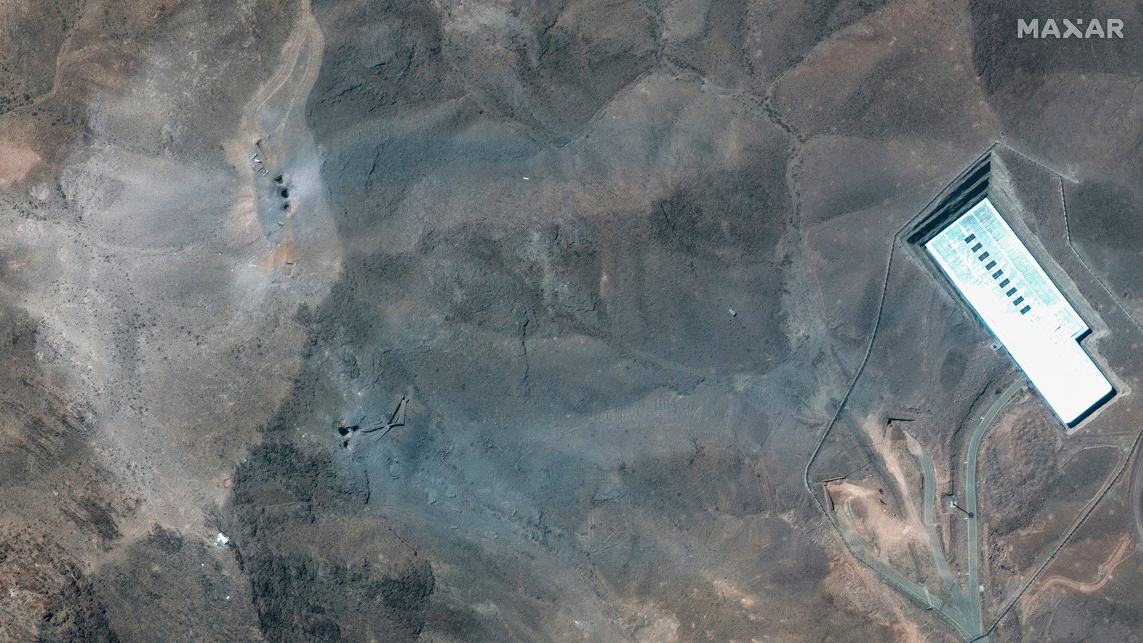
We asked ChatGPT to analyse a satellite image of Iran’s Fordow nuclear facility… here’s what it said:
 ChatGPT analysed this satellite image provided by Maxar Technologies. (AP Photo)
What the image shows:
* The image appears to be a satellite view of a fortified facility in a mountainous or hilly region.
* There’s a perimeter security fence (likely a high-security compound).
* Several roads and paths inside the compound suggest significant underground infrastructure.
* The most prominent visible structure is a large rectangular building (possibly an entrance or surface-level support structure for underground facilities).
* South-east of the large building, we see a lighter-colored area that seems to show:
* *Surface scarring*
* *Debris field*
* *Color changes consistent with recent impact or explosion*
* *Small dark craters or holes (possible penetrations)*
Does it show evidence of a bunker buster bomb?
A bunker buster bomb (typically designed to penetrate hardened underground structures) would have certain visible surface indicators depending on the type, yield, and target depth:
Story continues below this ad
Summary Analysis
* The image shows damage consistent with an airstrike, likely involving a precision-guided penetrator or bunker buster.
* The damage pattern suggests localized penetrative impacts — multiple possible penetrator strikes concentrated near or over the underground area.
* The absence of widespread surface collapse suggests either:
* The underground structure is very deep and reinforced.
* The strike targeted specific underground access points or vulnerable nodes rather than full structural destruction.
* This matches with the type of strike the US might employ against Fordow, which is known to have deeply buried centrifuge halls.
Caveat
This is a preliminary remote assessment based solely on open-source satellite imagery. Without ground-based confirmation (e.g., seismic data, on-site photography, or intelligence reports), the assessment of bunker-buster effects remains an educated interpretation.
© IE Online Media Services Pvt Ltd


Average Rating